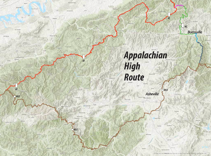
The Appalachian High Route is a ~ 330-mile loop that combines the Appalachian Trail, Mountains-to-Sea Trail, and Black Mountain Trail using the newly established “Burnsville Connector” as a connector. The route also provides access to nearly all the 6000+ peaks in the Appalachians. Along the way, it travels through three National Parks, three National Forests, and one State Park. I helped my friend, Jake Blood, come up with the idea for the Appalachian High Route as we poured over maps of Yancey County and wondered how to connect the best trails near Burnsville.
We also decided early on that we should reach out to any stakeholders involved in this route. So between Jake and myself, we contacted about 20 different partners that included land management agencies, trail organizations, and trail maintaining clubs – such as Mount Mitchell State Park, Friends of the Mountains-to-Sea Trail, and the Carolina Mountain Club. We wanted to give these organizations a heads-up about the formation of the route and ask for any feedback or suggestions. The response has been overwhelmingly supportive, but we also plan to keep these lines of communication open and use feedback from these entities to continue and shape the Appalachian High Route.
This past weekend, my friend Haley and I became the first two finishers of the Appalachian High Route. We wanted to make sure the Burnsville Connector was a viable hiking route before announcing it to the public. As a combination of trail, forest service road, and secondary roads we found that the route offered a nice mix of bucolic beauty, local history, scenic creeks – and a brewery. Yes, you have to be careful on the road sections, but there wasn’t much traffic except for 19E, which has wide shoulders and/or sidewalks, and there was always a place to step off when needed.
So… how do we get other folks out there hiking? Patches!!! (Plus maps and trail info.) We agreed early on that we wanted a patch for the route, because hikers will go to ridiculous lengths for a custom fabric patch. We are also creating special awards for the first 12 finishers of the Appalachian High Route. But in order to hike it, folks are probably going to need resources (even more than patches). And that’s what we are working on next.
Over the next few months, our goal is to finalize the route maps and then share them as a physical resource at the Burnsville Visitor Center, online, and through Hiking Apps such as Avenza and Gaia. We also plan to share important route information and updates on www.appalachianhighroute.com (in the works) and through our Social Media Accounts: Instagram – App High Route, Facebook – Appalachian High Route. Check out these resources over the next few weeks and months for helpful tips and news.
We are also hosting an informational meeting for the Appalachian High Route at 6:30 pm on August 4th at the Burnsville Library. This session is open to the public and we encourage interested hikers to attend.
In the meantime, if you want to adventure out on your own without the formal resources then you can use these basic maps and directions to complete the route.
Appalachian Trail (~ 135 miles) – The Appalachian High Route follows the A.T. between Clingmans Dome in the Smokies to Flat Top Road (FS 278) just north of Spivey Gap.
Mountains to Sea Trail (~ 155 miles) – The Appalachian High Route follows the M.S.T. between Clingmans Dome and the summit of Mount Mitchell.
Black Mountain Crest Trail (~ 12 miles) – The Appalachian High Route follows the Black Mountain Crest Trail for its entirety between the summit of Mount Mitchell and Bolens Creek Trailhead.
Burnsville Connector – (~ 26 miles) The Burnsville Connector is comprised of 3.7 miles of trail, 3.7 miles of gravel FS road, and 18 miles of paved secondary roads and/or sidewalks. At the northern end of the connector, it follows a gated/unmarked Forest Service Road from the intersection of the Appalachian Trail and Flat Top Road (FS 278) for 1.6 miles to reach Devils Creek Trail. It completes the 2.0 mile Devils Creek Trail then connects to the Lost Cove Trail for 1.7 miles before it eventually rejoins Flat Top Road (FS 278). From there, the connector follows Flat Top Road (FS 278) for 2.1 miles to reach White Oak Flats Road. Hikers are on White Oak Flats Road for 1 mile before connecting to US-19W. It follows US-19W for 3.0 miles to reach Coxes Creek Road. It then travels Coxes Creek Road for 4.0 to connect with Jack’s Creek Road. The route follows Jack’s Creek Road for 3.8 miles to reach 19E. From 19E, the Connector takes hikers 1.8 miles to access W. Main Street and Downtown Burnsville. Stay on this road for 1.5 miles as it changes from W. Main Street to Town Square to E. Main Street, then turn on Pensacola Rd. After .5 miles on Pensacola Rd take Wid Smith Road for .4 miles to reach Bolens Rd and then travel 2.0 miles to reach Watershed Rd and the Black Mountain Crest Trail.